Tongariro and Ruapehu are practically the only notable mountains on the North Island, if you do not count the free-standing Taranaki on the west coast. While I lived in Auckland, I often got out to this region, so over time I got to see it from different sides. I have walked the Tongariro Crossing several times: the full route, the way it is meant to be done, only once. The other two times I turned the route into a loop, which, to my mind, came out more interesting than the original.
This region has a quirk you quickly learn to account for in practice: the weather here decides almost everything. Because two large mountains stand in the middle of the plains, cloud gathers here very often, and conditions can change in a matter of hours. Catching a fully clear day here is not easy, and for Tongariro that is especially critical, since there are no other peaks nearby that could "rescue" the views if it all closes in. So I always try to wait for the perfect window, when the sky is as clear as possible.
On top of that there is the logistics. If you are coming from Auckland or Wellington, you need to sort out an overnight stay in advance and book a shuttle. The problem is that the forecast changes fast, and planning far ahead is almost pointless: the best conditions often only become clear a couple of days before the hike. As a result you can end up in a situation where the weather is perfect but all the shuttle spots are already taken, especially in high season. That is why I waited several months for the first window for this route.
I spent a long time deciding what difficulty to give the route, and in the end I went with medium, though it is medium on the edge of hard. Almost the whole route follows a wide, well-formed trail. There are markers in case of fog, and along the way there are even toilets. The elevation gain is relatively small and broken into several parts.
On the other hand, the route is long and tiring, more than twenty kilometres. The climb up Red Crater can be a serious test for an unprepared person, and in bad weather conditions quickly get much harder.
One thing worth keeping in mind separately is the nature of the terrain itself. Tongariro is an active volcano. Active does not mean it is constantly erupting with magma sloshing about somewhere, it means an eruption can happen at any moment. Before hiking in this area I always check GeoNet for any activity. But it is worth remembering that no matter what it says there, an eruption can happen suddenly and without warning.
My first hike on the Tongariro Crossing was in February 2024. I spent a long time watching for a suitable weather window, and once I was finally sure the conditions were good, I quickly booked a shuttle and a place to stay. That same evening after work my wife and I set off for the volcano, drove to the campsite, and spent the night there. In the morning we had breakfast and by seven were at the car park, where the bus took us to Mangatepopo.
The route roughly divides into two parts. The first is more varied and spectacular: the valley at the start, then the climb up the Devil's Staircase alongside frozen lava flows, then out onto the flat South Crater, the final climb up Red Crater, and the descent to the Emerald Lakes.
After that the second part begins. First a little more along the slopes of Tongariro to Blue Lake, and then a long descent to the Ketetahi car park. This is the stretch many consider the dullest part of the route, and I understand them.
On the first section, up to the Devil's Staircase, you cover 4.5 kilometres and gain 250 metres at an easy pace. The section is simple and passes easily. By this point more than a quarter of the total climb is already behind you, though by distance you have not yet done a quarter of the route. Right at the start you can catch a glimpse of Ruapehu, which later hides behind the terrain, while on the right the conical Ngauruhoe looms the whole time, like Orodruin, where Frodo and Sam carried the ring.
Mount Doom
Peter Jackson used the Ngauruhoe volcano as Orodruin (Mount Doom) in "The Lord of the Rings". So the feeling that you are walking through Mordor does not come from nowhere. The last eruption of Ngauruhoe was in 1977, and over the whole history of observation it has erupted dozens of times. Ngauruhoe is itself part of the Tongariro volcanic massif, though from the outside it looks like a separate mountain.
The traces of past eruptions are clearly visible all around, frozen lava flows can be seen on both Tongariro and Ngauruhoe. Some of Tongariro's slopes erupted relatively recently, in 2012.
A couple of hundred metres before the end of this stage there is a side branch to the small Soda Springs waterfalls. Honestly, I have never once turned off to them, since the waterfalls and the stream are fairly small and not worth it.
The next section is the Devil's Staircase. Despite the name, it is not a staircase in the literal sense, but a steep climb up an uneven slope over irregular natural steps. The climb runs about 1.8 kilometres and takes you roughly 300 metres higher. As you gain height, in clear weather you can spot the silhouette of Taranaki on the horizon, about 130 kilometres away.
After climbing the "staircase", you come out onto the South Crater. Here begins about a kilometre of almost flat ground, a kind of breather after the first climb and before the next, harder one. The landscape changes sharply here. You get the feeling you are no longer in New Zealand but somewhere on Mars: a lifeless expanse with no vegetation, yellow-orange ground, sharp rocks and crags, Ngauruhoe rising on the right and the summit of Tongariro on the left. I remember well how much it impressed me the first time.
The next stage is the jewel of the whole route: the top of Tongariro's most famous crater, Red Crater. Here you face the final climb. There is no real trail any more, but working out where to go is not hard. I remember walking with a friend, and just before the climb he let slip that "this Tongariro Crossing of yours is not that hard", which he later regretted.
You only need to climb 175 metres up and 900 metres forward, but because the climb is steep and in places you almost have to scramble over rocks, for some people it can be a serious test. My friend was pretty wrecked after this section. In winter, if there is snow here, it is also the most dangerous spot: ice builds up heavily from melting and strong winds, and there is a risk of avalanches.
But at the top, on the crater rim, a panorama opens up in every direction: onto Ngauruhoe, onto the various parts of Tongariro, onto the vent of Red Crater, and onto the emerald acidic lakes below. This is the place where you can and should sit down, have a snack, and enjoy the views.
And besides, since there is volcanic activity beneath you, on a cold windy day you can sit right down on the ground and it will warm you.
At a relaxed pace you reach the top of the crater in about 2.5 hours, 3 at most.
Remember this spot, we will come back to it: this is exactly where my secret branch off the main route begins.
But first the classic version. Next comes the descent to the emerald lakes, and for some it turns out to be the least pleasant part of the whole route. The slope is covered in fine volcanic scree, your feet slip constantly, and every step down is more like a controlled slide. The most comfortable way down here is to go slightly sideways at a light jog, letting the scree carry your feet down. If you try to descend with a normal step, you very quickly understand why there are so many people around who suddenly end up sitting on the ground.
At the bottom you can take a few more photos with the lakes and carry on. The lakes are acidic, and steam rises from the ground nearby.
After another kilometre or so, you reach Blue Lake. If you turn around, new views of Red Crater open up, and from this angle you can clearly see its shape and outline, along with Ngauruhoe and, once again, Ruapehu peeking out a little.
As I said above, the trouble with Tongariro is that the second half of the route, after Blue Lake, is very dull. Ahead lie 11 kilometres of monotonous descent. For views there is only Lake Taupo in the distance and bits of Tongariro's small craters along the sides of the trail.
You descend for a long time, and towards the end you start asking yourself existential questions about why you need any of this. When I was putting together this report, I found literally a couple of photos from this section, because there is not much to shoot there.
The whole track from start to finish took us about eight hours. When we finished, our feelings were mixed: the first half was very beautiful and interesting, and then it was all spoiled by the monotonous descent. But overall I was satisfied, because the Tongariro Crossing is one of those routes you have to walk in full at least once in your life, and we managed it. Plus the weather that day was perfect, not a cloud, so it all worked out.
All the same, I could not shake the thought that there had to be a way to make the route more interesting. Six months later I found it. Though here you have to meet a few conditions and put up with a couple of limitations.
The main condition, besides the weather, is to do the route out of season, when there are no parking restrictions at Mangatepopo. You also have to accept that there will be no descent to the emerald lakes (you will have seen plenty of them from the top of the crater anyway) and no view of Red Crater from the Blue Lake side. But in return there will be cooler things. I have walked this branch twice, in August and June, and both times there was almost no snow, even though it was winter. If it is snowy, do not use this report as a guide, the conditions will be completely different, and in snow, as they say, you will be lucky to even reach Red Crater.
Unfortunately I do not have a GPX track for this version, but here is a rough plan of the route on Google Maps.
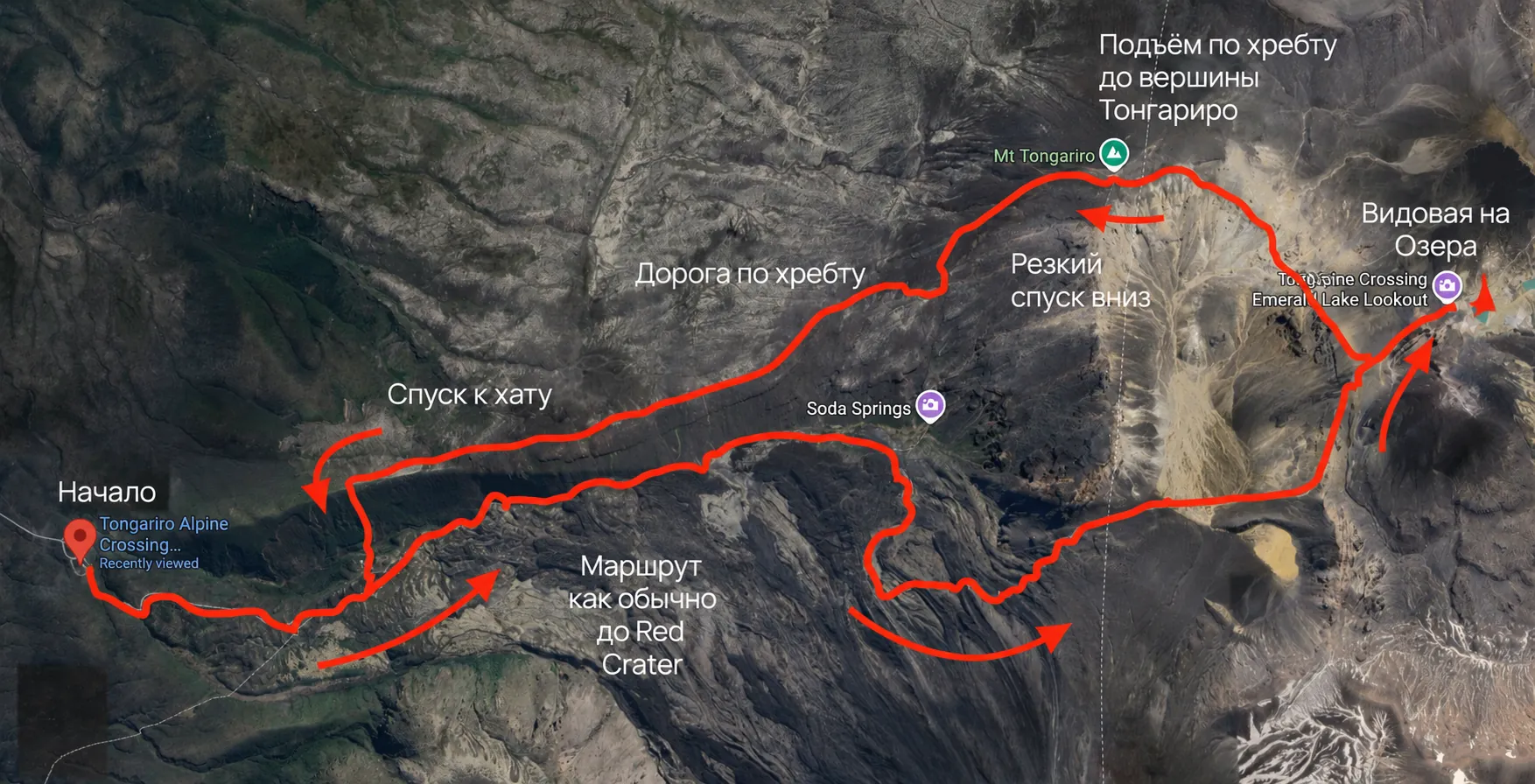
So, let us mentally return to the top of Red Crater.
I discovered this route by chance. Originally my friend and I planned to just reach the crater and head back to Mangatepopo, but in the end we found a far more interesting option (P.S. since I walked this route twice, from here on there will be a mix of photos from both hikes).
Instead of descending back to the South Crater, before the descent begins you need to head right and slightly up along the ridge. There is a small sign here reading "NO PATH AHEAD", and, as you might guess, that is exactly where we are headed.
For orientation: in Organic Maps you can set a point to Mount Tongariro 1967 m, and the app will build a route (which was not possible before). Essentially the trail runs along the ridge around the South Crater. There is no trail as such, but no difficult sections either. You need to cover about a kilometre and a half and gain roughly 150 metres. Along the way new angles on Ngauruhoe appear, and a view of Tongariro's northern crater from the other side, looking more like a plateau.
The final point before the descent is the summit of the Tongariro volcano. From here there is a view of Ngauruhoe, which I hope has not bored you yet, and Ruapehu standing behind it. There are very few photos from this angle online, few people make it here, because in 99 percent of cases everyone takes the main route.
Next comes the hardest part of this route. Ahead is a descent straight down from the volcano to the ridge that, at the start of the route, was to the left of the main trail, above the line of Mangatepopo Hut and Soda Springs.
The slope did not look very welcoming, but there was no other way anyway, so we had to go down (you could actually just go back to Red Crater and descend by the main trail, but our motto was recklessness and valour). The descent here is noticeably steeper than from Red Crater, the ground is loose, the rocks are sharp, and falling here is far nastier. I managed to test this in practice in both places, so I have something to compare: on this slope the consequences feel far more painful. You can go a bit further left down the rocky slope, it is safer there, but also slower.
The first time I was here, having come down off the rock, we met some local climbers who were returning to the car park by the same way. We joined them, and it paid off, because they showed us where to go next. On the final ridge there is something like a trail, people do walk here after all, but it quickly fades and only the direction remains. It is hard to get lost, though.
The main aim is to descend down and to the left off the ridge, and here it is worth being careful: almost everywhere the descent is very steep, with drop-offs in places. You need to go until you are level with Mangatepopo Hut, and there, in the bushes, is a barely visible trail down to the Soda Springs stream and up to the hut. After the hut there is about a kilometre and a half left to the car park, and the loop closes: you have gone through Red Crater and the Tongariro summit and come back to the start.
To sum up, the Tongariro Crossing is a must-do, especially if you live on the North Island. Should you at least reach Red Crater and the emerald lakes? A hundred percent. Should you walk Tongariro in full? More likely yes than no (at least once). And is the loop version from this report worth trying? If you have the fitness and the desire to walk wild trails where almost no one goes, and to see Ngauruhoe and Ruapehu from an unusual angle, then absolutely yes.
P.S. I have two more routes from this region up my sleeve, which I will cover in future reports.