Pouākai Tarns is part of the longer multi-day Pouākai Circuit, which loops around Taranaki. I have not walked the whole circuit myself, but as far as I know Pouākai Tarns is one of its most popular points, and you can get here in a single day.
I write a great deal about always trying to catch good weather when I go into the mountains. That is hard enough around Tongariro and on the west coast of the South Island, but with Taranaki it is the single biggest problem.
Taranaki is a lone volcano on the west coast of the North Island, with no other mountains within a radius of more than a hundred kilometres. Which means it pulls in cloud constantly.
Why the volcano is almost always in cloud
Taranaki stands alone in the middle of a plain, directly in the path of the westerlies off the Tasman Sea. Moist sea air runs into a mountain 2,518 metres high and is forced upwards. Higher up the air cools, the moisture in it condenses, and cloud forms right above the mountain. The key point is that the cloud is born on the mountain itself rather than blown in from somewhere else. The sky all around can be completely clear and the volcano will still be covered.
So catching good weather here is quite hard. A trip to Taranaki was an unfinished piece of business for me for a long time. I flew into New Plymouth twice for work and both times spent several days in the area. In all that time the mountain came out of the cloud exactly once.
Broadly there are windows when the odds of seeing it clear are better: morning and evening. During the day, even with a good forecast, there is a fair chance cloud will move in and cover the volcano at least partly.
Then on one April day, right before the weekend, a good forecast finally lined up. After months of watching the weather I gathered friends, we booked a place to stay, and the decision was made to go. The original plan was to arrive in New Plymouth and walk the next morning, but the day before we left the forecast started shifting and the good weather window moved to the first day. That meant leaving early in the morning, walking the same day, sleeping over, and driving back.
So we set off from Auckland in the morning. The road runs along State Highway 3. About a hundred kilometres before New Plymouth, as you drive along the coast, Taranaki starts to appear in the distance. When we came out onto the road with that view, I saw the mountain was fairly thoroughly wrapped in cloud, even though the forecast for that hour had been very good. There was nothing to be done, three hours of driving lay behind us, so we carried on.
On the way to Taranaki, if you are coming from Auckland (or on the way back), I strongly recommend stopping at Three Sisters beach. There are several caves, cliffs, and sea stacks of various shapes along it. You can only get there at low tide, so check the tide table for the day and allow a couple of hours to see it all. The beach is about an hour north of New Plymouth.
The Three Sisters sea stacks
Sea stacks are free-standing rocks left behind in the sea as the waves gradually wear away the rock around them. First the surf punches a cave into a headland, then the cave becomes an arch, and in time the arch collapses, leaving a solitary stone pillar. Here these stacks reach about 25 metres, and the erosion is still going on right now. In the early 2000s there were four sisters, and by 2024 only two were left. The neighbouring Elephant Rock lost its trunk in 2016, so all that is left of the elephant now is an arch. Which means photographs of this place from ten years ago already look noticeably different from what you will see today.
If you cannot make it down or have no time, you can at least pull in at the lookout over the beach.
Back to Taranaki. By the time we pulled into the car park the mountain was slightly less covered on the side we were going to walk. We decided to go anyway, hoping the weather would shift again. For what it is worth, there was hardly any cloud around the mountain and the sun was out.
From the car park you walk about 600 metres to the edge of the forest. From there a long stretch of boardwalk begins. Most of the route is fairly dull because it runs through forest, but thankfully it is not difficult: the whole track is very well built.
Although the track is fairly long, 12 kilometres return with more than 700 metres of climbing, the gradient is even rather than sharp and the surface is good. So it does not wear you down that much physically (you will still be tired by the end), and technically it is very easy.
After 4.2 kilometres there is the first viewpoint on the route: the plain around Taranaki and the sea in the distance. A good place to catch your breath before carrying on.
Another kilometre and a half brings you to Pouākai Hut, one of the huts on the circuit. There is a toilet and somewhere to sit and eat. To stay the night you have to book a bunk. When we walked in April 2025 it was still being finished.
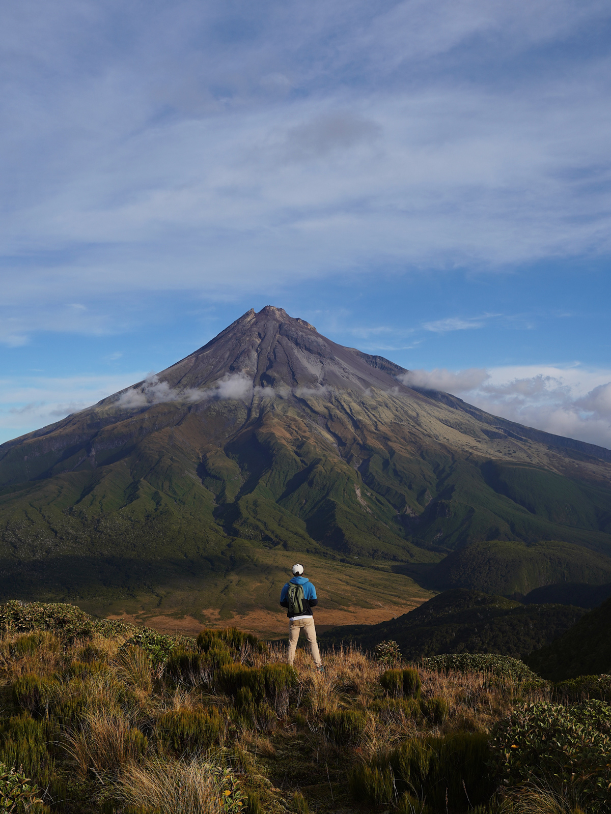
From here it is another 200 metres before an epic view of Taranaki opens up. When we came out it was four in the afternoon, the sun was heading for the horizon, and the cloud had almost cleared off the mountain.
In shape Taranaki is a near perfect cone, which is why so many people compare it to Mount Fuji.
Taranaki and Fuji
The resemblance is not a coincidence: both are stratovolcanoes, meaning they grew in layers of lava and ash around a single central vent. Both also stand apart from the main mountain ranges, which is why their symmetrical cones are visible from so far away. That shape is typical of volcanoes that grow fairly evenly in all directions, with no surrounding terrain to get in the way. The likeness is strong enough that in 2003 Taranaki played Fuji in The Last Samurai. Rather than film in Japan, the production used the New Zealand volcano as a stand-in. The difference is scale: Fuji rises to 3,776 metres, Taranaki to 2,518. The volcano's other name, Mount Egmont, was given by James Cook in 1770. Today the official name of the mountain is Taranaki Maunga.
I have been to Japan and seen Fuji, incidentally, and I can say they really are alike. But Fuji is of course more epic and more monumental, because it is considerably higher. Although that sense of scale may have come from the fact that Fuji's summit was under snow, while here we were in summer. Here are the photos.
The walk does not end there: you have to carry on slightly downhill for another 800 metres or so to the Pouākai Tarns themselves.
There you will find the famous viewpoint looking at Taranaki. If you are lucky and there is no wind, the mountain reflects perfectly in the water.
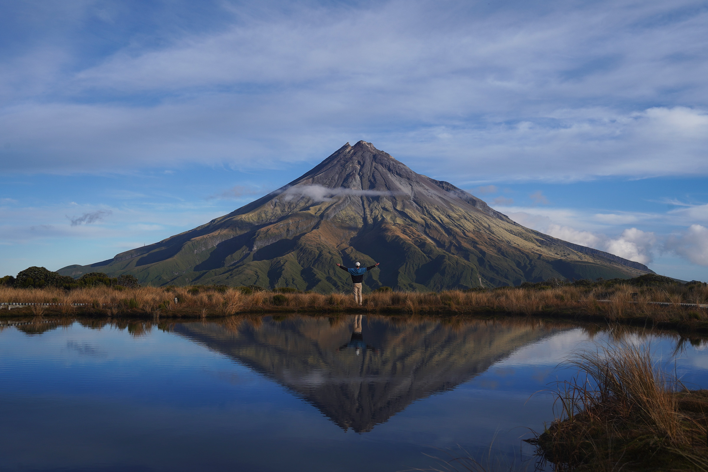
You can also sit down and eat here once you have taken your fill of photos. We reached this point in about two and a half hours at a very unhurried pace.
You can climb Taranaki itself, by the way, but that is a considerably tougher undertaking: a lot of elevation, no track, and loose scree. I have not been up there myself, because I do not see much point in it. Taranaki is beautiful seen from the outside, whereas from the summit all you get is the plains stretching away, the sea, and Tongariro and Ruapehu a couple of hundred kilometres off like small dots in good weather.
You go back down the same track. We started back as the sun was almost gone, and walked part of the return in the dark. But as I said, the track is good and impossible to lose. Even so, take a head torch so you do not misjudge the steps.
All up, allow around five to six hours for the return trip depending on your pace.
In closing I would say the route is worth doing. You will not come away with all that many photos, since in practice there are only two angles on the viewpoint, but Taranaki is a very beautiful volcano with a charm of its own, and it does not feel as lifeless as Ruapehu or Tongariro. There is no Mordor atmosphere here; the volcano itself is fairly green and there is plenty of vegetation around it.
But unfortunately you have to be ready for the possibility of coming here more than once, because cloud-free weather is not easy to catch. Even if you set out under clear skies, there is no guarantee the mountain will not be covered by the time you reach the viewpoint. Or the other way round, as it went for us: start under cloud and arrive at a perfectly clear viewpoint.